Aerial & Drone Photography Ireland | Professional Industrial Photographers

Aerial & Drone Photography Ireland

Yann Industrial Images provides professional aerial and drone photography for Irish businesses requiring elevated perspective imagery. With 41 years of commercial photography experience and fully licensed drone operations, we deliver aerial photography that serves construction documentation, facility overviews, property development marketing, and infrastructure project management across Ireland.

Based in Galway, we combine technical expertise in aerial photography with an understanding of commercial requirements. Whether documenting multi-million euro construction projects, capturing facility expansions for investor presentations, or providing property development marketing imagery, we deliver professional aerial photography that meets Irish business standards for quality and regulatory compliance.

Aerial View of Construction Site

Call & Discuss Your Aerial and Drone Photography Requirements

Book Early

Why Irish Businesses Choose Our Aerial Services

Licensed Drone Operations Meeting Irish Requirements

Licenced Drone Operations

Fully Compliant Operations

Licensed drone operations meeting Irish Aviation Authority requirements, comprehensive aviation insurance, adherence to Irish airspace regulations, and established safety protocols. We handle all regulatory compliance including flight notifications, airspace clearances, and restricted zone approvals when required.

Established Track Record

Established Commercial Track Record

Over four decades providing commercial photography to Irish businesses, with drone operations integrated into our services since 2016. We understand project timelines, procurement processes, and the documentation requirements Irish businesses face for construction management, investor reporting, and marketing applications.

Technical Aerial Imaging

Technical Aerial Imaging Capability

Professional drone equipment capturing high-resolution aerial imagery suitable for large-format printing, technical documentation, and marketing applications. We deliver orthorectified imagery for site planning, oblique perspectives for marketing materials, and consistent documentation series for progress tracking over project lifecycles.

Ireland-wide Service

Responsive Ireland-Wide Service

Galway-based operations with availability throughout Ireland. We schedule aerial shoots around weather windows, coordinate with ground operations, and deliver imagery within tight project deadlines. Priority scheduling available for time-sensitive construction milestones or investor presentation requirements.

What We Deliver for Irish Businesses

Aerial Imagery That Serves Your Business Objectives

Construction Progress Photography

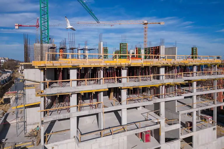
Construction Progress Documentation That Satisfies Stakeholders

Regular aerial documentation demonstrating project advancement and milestone completion. Your project management teams get the visual proof investors and clients expect for €1M-€500M+ construction projects, whilst your communications teams receive marketing-ready imagery for stakeholder updates and media announcements.

Facility Overviews

Facility Overviews That Communicate Scale and Capability

Aerial facility photography showcasing your operational scale, site layout, and infrastructure investment. Your business development teams get compelling imagery for capability presentations and tender submissions, whilst your corporate communications receive professional facility photography for annual reports and investor materials.

Property Development Package Package

Property Development Marketing That Drives Sales Decisions

Aerial perspectives demonstrating location advantages, site context, and development scale for commercial and residential property projects. Your sales and marketing teams get the elevated perspectives that differentiate your property developments and accelerate buyer decision-making in competitive Irish property markets.

Infrastructure Documentation Photography

Infrastructure Documentation That Demonstrates Project Delivery

Systematic aerial documentation of infrastructure projects including roads, utilities, renewable energy installations, and civil engineering works. Your project teams get the comprehensive visual records required for project management, whilst clients receive the documentation demonstrating successful project completion and regulatory compliance.

Pre-development Photography for Planning

Site Survey Imagery That Supports Planning Applications

Pre-development aerial photography supporting planning applications, environmental assessments, and site feasibility studies. Your development teams get the comprehensive site documentation planning authorities expect, accelerating approval processes for commercial developments throughout Ireland.

All aerial photography includes:

  • High-resolution imagery suitable for large-format printing
  • Multiple perspectives (cardinal directions, oblique angles, overhead orthogonal)
  • Professional editing and colour correction
  • Georeferenced imagery when required for planning applications
  • Weather-contingent scheduling with flexible rescheduling
  • Fast turnaround (48-72 hours standard, rush available)

How We Work With You

Pay-Per-Shoot

Single aerial photography session charged per day or half-day. Suitable for one-off requirements including facility overviews, property marketing imagery, or immediate project documentation needs. Includes site visit, aerial photography session (weather-dependent), professional editing, and high-resolution image delivery within 48-72 hours.

Progress Documentation Series

Scheduled aerial photography over project duration (3-36 months). Monthly, fortnightly, or weekly shoots maintaining consistent angles and perspectives for effective progress comparison. Discounted rates for multi-shoot commitments. Suitable for construction projects, facility expansions, or infrastructure developments requiring systematic documentation for stakeholders over extended timelines.

Annual Retainer Agreement

Ongoing aerial photography service for businesses with continuous requirements across multiple projects or sites. Priority scheduling, preferential rates, and guaranteed availability during critical project phases. Suitable for construction firms, property developers, or infrastructure companies requiring regular aerial photography support throughout the year.

Rush Service

Priority aerial photography for urgent requirements with 48-72 hour turnaround from shoot to delivery. Premium rates apply. Weather-dependent but prioritised scheduling. Suitable for time-sensitive presentations, immediate marketing requirements, or unexpected project documentation needs requiring expedited delivery.

Sectors We Serve Throughout Ireland

We provide aerial photography for Irish businesses and projects where elevated perspective adds genuine value:

Construction & Development

Construction & Development faces investor and client demands for visual proof of project advancement. Monthly aerial documentation demonstrates progress milestones, tracks schedule adherence, and provides stakeholder confidence for projects from €5M housing developments to €500M infrastructure works. Cork, Dublin, and Galway construction markets represent our core client base.

Property Development

Property Development requires aerial context showing location advantages and site surroundings that ground-level photography cannot capture. Commercial developments in Dublin docklands, mixed-use schemes in Cork, and Galway residential projects all benefit from aerial perspectives demonstrating transport links, amenity proximity, and neighbourhood context that influence buyer decisions.

Renewable Energy Projects

Renewable Energy Projects spanning wind farms, solar installations, and anaerobic digestion facilities require systematic aerial documentation from planning through construction to operational stages. Turbine arrays in Donegal, solar farms in the midlands, and biogas facilities nationwide need aerial photography demonstrating environmental integration and construction quality for planning compliance and investor reporting.

Infrastructure Development

Infrastructure Development including motorways, wastewater treatment facilities, and telecommunications networks demands comprehensive aerial documentation. Roads authorities, utility companies, and telecommunications providers require elevated perspectives capturing project scale, environmental context, and construction progress that ground-level documentation cannot adequately provide for projects spanning kilometres rather than metres.

Large-Scale Agriculture & Forestry

Large-Scale Agriculture & Forestry operations covering hundreds or thousands of hectares benefit from aerial surveys showing field boundaries, drainage systems, crop conditions, and forestry management. Tillage farms, livestock operations, and commercial forestry require aerial imagery for land management, environmental compliance, and farm improvement grant applications where ground-level documentation proves insufficient.

Aerial Photography FAQ

We hold all required permissions and insurances for commercial drone operations throughout Ireland. We handle flight notifications to the Irish Aviation Authority, coordinate airspace clearances, and manage restricted zone approvals when required. All operations comply with Irish aviation regulations and safety protocols.
Aerial photography requires suitable weather conditions (adequate light, acceptable wind speeds, no precipitation). We monitor weather forecasts closely and reschedule shoots when conditions are unsuitable. Flexible rescheduling ensures you receive quality imagery whilst maintaining project schedules. Most projects allow 2-3 week windows accommodating weather contingencies.
Yes, with appropriate approvals. Ireland has restricted zones around airports and sensitive locations. We handle all required clearances and notifications for operations near controlled airspace. Advanced notice required for restricted zone operations (typically 5-10 working days for approval processing).
High-resolution imagery suitable for large-format printing, technical documentation, and marketing applications. Standard deliverables are high-resolution JPEGs. RAW files available upon request. Imagery suitable for billboard printing, technical planning documents, or website marketing without quality compromise.
Yes. Georeferenced imagery available for planning applications and technical documentation. Orthorectified imagery (geometrically corrected aerial photography) suitable for site planning, boundary surveys, or integration with GIS systems. Specify requirements when requesting quotes for appropriate workflow and pricing.
Standard scheduling within 7-10 days subject to weather windows. Priority scheduling available for urgent requirements (48-72 hours) at premium rates. Construction progress documentation series scheduled at regular intervals over project duration. Flexible rescheduling accommodates weather delays without additional charges.

Request Your Aerial Photography Quote

Professional aerial and drone photography for Irish construction, property development, manufacturing, and infrastructure projects. Contact Yann Industrial Images to discuss construction documentation, facility overviews, property marketing, or infrastructure project requirements.

Response commitment: We respond to all aerial photography enquiries within 24 hours. Scheduling typically available within 7-10 days subject to weather conditions.
Priority scheduling available for urgent requirements.

Scroll to Top

Aerial & Drone Photography
Quote Form

We will get back to you as soon as possible

Yann Industrial Images Logo
Privacy Overview

This website uses cookies so that we can provide you with the best user experience possible. Cookie information is stored in your browser and performs functions such as recognising you when you return to our website and helping our team to understand which sections of the website you find most interesting and useful.

Privacy Policy
Cookie Policy